Posts

Showing posts from February, 2011

Tremadog

Image
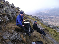
Had a great day climbing with Andy today. We did Valerie's Rib (HS) and Rio (S). The weather was fantastic and was very warm out of the wind - Spring has arrived at last (well....at Tremadog at least !!). Photo: Andy on the second pitch of Valerie's Rib

WGL Assessment Day 3

Image
It was the final day of the WGL assessment today. The weather was, again, a bit on the changeable side but we managed to find a nice spot around Moel Faban (above Bethesda). The weather did improve after lunch but it was bitterly cold with a dusting of snow above about 700m. A great day with fine views over towards Anglesey .

WGL Assessment Day 2

Image
We ventured over to Dolwyddelan today and parked up at the car park near Carrag Alltrem. The plan for the day was to do a journey up the valley over to Foel Fras and then Moel Penamnen (623m) before making our way back down into the valley. Some of the team gave their 5 minute presentations during the day and I also had a look at the equipment they would carry as a leader. Apart from a bit of hail it was dry all day but with a cold wind. Photo - Lunch stop and Moel Penamnen in the background

Walking Group Leader Assessment

Image
I'm over at Plas y Brenin again this weekend working on a WGL assessment. There are 7 candidates on the course who mostly work on the Duke of Edinburgh Awards scheme. We were over by the North Wales coast today in the Tal y Fan area looking at navigational skills. Once we returned to the centre and had dinner we left at about 8 to carry out some navigation in the dark. Unfortunately, it had been damp and dreary all day around Capel Curig but we were rewarded with lovely weather during the day but the night nav was quite wet. The photo is of the team at Maeni Hirion above Penmaenmawr.

Navigation Day 2

Image
It was day 2 on the winter navigation course at Plas y Brenin today. We considered the weather forecast and Colin and Carl discussed what they would like to get out of the day so we decided that The Moelwynion would be a good choice. We went up Cnicht from Gelli Iago and then navigated over to Llynnau'r Cwn and down to the road via Llyn Llagi. If you'd like to see more photos of the course please follow this link . Top: Colin and Carl on the summit of Cnicht. Bottom: NE ridge of Cnicht with Llyn y Biswail.

Plas y Brenin

Image
I'm working for Plas y Brenin this weekend running a winter navigation course. As there isn't much in the way of winter conditions we decided that a long mountain day would be best so that we could look at map interpretation, compass work, pacing, timing and the use of 1:50,000 and 1:25,000 maps. We were dropped off at Pen y Pass and then made our way up Glyder Fawr and then followed the ridge all the way back to Plas y Brenin via Glyder Fach and Y Foel Goch. We left the centre late so that we could do some night nav on the way down and got back just in time for supper at 7. The photo's are of Tryfan and Colin and Carl approaching the top of Glyder Fawr.

Moel Eilio, Foel Gron and Foel Goch

Image
As there was a good weather forecast today I decided to venture up Moel Eilio (726m) and then follow the ridge to Foel Goch (605m) via Foel Gron . There was a surprising amount of people around today doing this fantastic circular trip. It felt quite cold in the wind but it stayed dry all morning with the cloud cover just above the tops (apart from Snowdon !). I tracked my journey with Endomondo so if you're interested click here . Top photo - Llyn Dwythwch and Elidir Fawr Bottom photo - Moel Eilio with point 629m in the foreground.

Winter Skills - Day 2

Image
The weather wasn't so good today with a lot of mist and rain around. We covered equipment choice indoors and crampon work on the "glacier" in the trees during the morning and then we spent the afternoon looking at basic ropework and belaying techniques. As you can see from the photo's, the weather did improve in the afternoon which made the session even more constructive. You can check out more photo's on my Flickr site by clicking here .

Winter Skills Course!

Image
I'm working on a winter skills course for Plas y Brenin this weekend but the conditions are far from perfect for winter skills. We ventured up Pen yr Ole Wen (978m) and Carnedd Dafydd (1044m) but, as you can see from the photos, there isn't much in the way of winter conditions in Snowdonia at the moment. We covered subjects such as navigation, scrambling on rocky ground, mountain safety, route finding, equipment and tried to put it into a winter context. It was a stunning day and the group were very enthusiastic.

Moelwyn Mawr and Moelwyn Bach

Image
The north west ridge of Moelwyn Mawr viewed from the summit Moelwyn Mawr and Snowdon from the summit of Moelwyn Bach What a fantastic day. Light winds, blue skies and cold temperatures combined to make a stunning day out on the hills. I made an ascent of Moelwyn Mawr (770m) and Moelwyn Bach (710m) from Croesor today and didn't meet a soul all day. There was just a dusting of graupel from about 700m and a bit of ice in the shade. I tracked my route with Endomondo so if you'd like to take a look click here .

Snowdon

Image
Had a quick jaunt up Yr Wyddfa this morning with the dog. The weather was good up to Clogwyn Station but the wind soon picked up and the cloud base was at about 800m (as was the freezing level). The wind was pretty strong at times and there was quite a lot of riming on the rocks but the Llanberis path was clear of snow and ice apart from some ice by the old stables below Carnedd Ugain. I logged the trip on Endomondo if any one's interested - Click here

A nice day despite the bad weather forecast

Image
Birch Polypore or Razor Strop Fungus (Piptoporus betulinus). Llyn Padarn and the Llanberis Pass